
Acland’s Letters: Sixth Letter
Gaspé Bay and the Saguenay
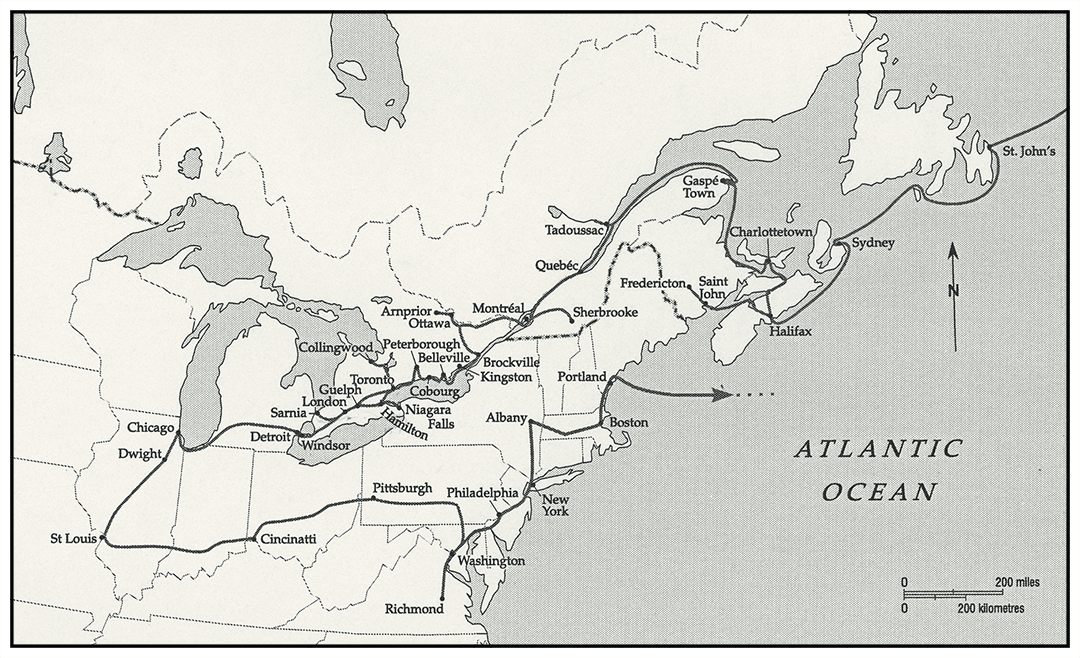
Following a brief diary entry for the Gaspé and the Saguenay region, Acland resumed letter writing with a description of their entry into the Canadas at Gaspé Bay followed by a letter to his seven sons from the St Lawrence and Saguenay Rivers.

Sunday 12. Do not reach Gaspé till past dark.
13th Sir Edmund Head to breakfast – Captain Retallack his aide de camp – get ashore [aground] in Gaspé Harbour – two hours in getting her off – Man overboard – saved. Executive Council on board – Leave in two steamers. Dense fog.
Round Cape Gaspé – Fire guns & rockets every half hour. Run up St Lawrence – Geology (Sir W. Logan).
14th Run up St Lawrence. Heavy head wind – reach mouth of Saguenay at daylight of 15th.
15th Run aground on Bar Reef at entrance of Saguenay. Happily get off, tide rising before noon. On board Governor’s steamer, Queen Victoria, up Saguenay, wet day. Executive Council on board. Return at night.
16th 6 A.M. On board Victoria up Saguenay 15 miles – to Marguerite river. Canoe expedition up rapids & down again. On board at 9 P.M. – Governor General, & Governor of Nova Scotia to dinner at 9:15.
4 A.M. Under weigh for Quebec. To anchor at 6 P.M. off Crane Island 30 miles from Quebec and enter Quebec 4 P.M. tomorrow.
18th Letters to be posted on board outward bound Steamship this morning as she passes at 12.
Gaspé bay
Mouth of St. Lawrence
August 12, 1860
Entry into the united Canadas
We have steamed up from Prince Edward’s Island Charlotte Town since yesterday at 2 – and having passed within gunshot of Percé head, we have run into Gaspé bay, a point of rendezvous with the Governor General of Canada. It is just sunset as our great ships grope in twilight into the wild bay and see deep in its recess two small steamers barely visible. The deep gloom is on the heights – the calm twilight lies on the still water, and gliding on noiselessly we come to an anchor. Tomorrow we are off again for the St. Lawrence.

The River St. Lawrence, near Quebec
August 18, 1860
My dear boys,
The waterways
You must imagine us having entered the mouth of the River St. Lawrence. The “Hero”, a line of battle Ship, the “Ariadne”, a great frigate of 68 pounders & the “Flying Fish”, having also the Steamer of the Governor General of the Canadas, Sir Edmund Head, and another Steamer with the Executive Council – We arrive off the mouth of the Saguenay, a small river compared to the St. Lawrence,11 but still more than a mile wide, in some places three miles wide, and 100 fathoms [600 feet or about 188 metres] deep and more, that is three times as deep as St. Mary’s Spire [the Oxford University Church]. The Pilot not being skilful ran us up on to a rock, which might have been of great danger, but happily we were got off with only some damage to our fore foot, that is the front of the keel.
You should understand that the St. Lawrence is the great river which drains all the lands about it and all the Canadas: including the great lakes, and the Niagara. It is as wide at the Saguenay as from Oxford to Woodstock [8 miles, 12.8 kilometers], at the least: so wide, that is, that a very large barn quite White can be seen only as a pins point. The shore which is very high on the North side, is covered with Pine Forests that no man has touched – the colour is splendid for the Rock is a beautiful gray – the pines are a dark green – the burnt parts of the forests (for many parts are accidentally burnt) are of a deep red, and the water a delicate blue.
The St Lawrence River and the chain of the five Great Lakes penetrate 3,058 kilometers (1,900 miles) into the heart of North America.
Geology
The world was once a melted ball of burning lava22 – as it whirled round & round it got cooler on the surface – and the surface became hard as the rind of an orange – but still elastic – it therefore was able to bend & did bend. But it was often broken through by the melted heavy mass within it – and then the melted mass poured over the rind – and as it passed through it and over it scorched and altered its shape and its colour, and its composition. Furrows & hills were made. And as the vapours fell on the surface the oceans were made in the hollows; and then the ice formed in the parts away from the sun. The ice melted in summer and sent great streams of water, and of ice floating thro’ the Furrows – The warm streams of the ocean too coming up from the equator washed these places – and so made great varieties of habitation for the animals that before the creation of Adam lived & died in these waters & continents. All this went on for a long long time.
Now the River St. Lawrence is one of the places where much of this can be seen, on a very large scale. The great outlet of the waters is very great. The surface of the earth is very uneven, the crust of the Earth is very much changed – and all for good. It is very fertile. On the high parts have grown for thousands of years great Forests to provide wood for our houses; and the waters washing down have filled the valleys with rich soil to grow corn and to make gardens. The ancient people of the Land the Indians still hunt wild animals in the Forests. The French who came here 300 years ago live near the shore – cut down the Forests & till the ground.
They speak French and sing old Norman songs now forgotten in France. They are quiet people who live at home, all on the shore of the great River.
And then came the English – who are now kind to the Indians & to the French – who build great ships & send them loaded with pine trees cut into planks to England & all the world that wants them.
All this I see on the St. Lawrence and on the Saguenay.
En route from the Gaspé, Acland read the work of Sir William Logan, head of the Geological Survey of Canada whom he would meet in Montreal.
Saguenay River
We steamed up the River between precipices of the altered rock,33 a kind of granite, squeezed into all shapes, altered into many kinds – Great pines were on the summits – deep gulfs of 1000 feet of water below us.
Mr. Price was with us. He rents from the Government of Canada the whole river. It extends very many miles, perhaps 150 – and still further thro’ lakes – He employs 3000 work people. He has built saw mills at the streams – of which one cost £50,000.44
As a respite before the demands of the tour of the Canadas, the royal party enjoyed two days among the sublime natural beauty of the Saguenay River which by mid-nineteenth-century had been made accessible as a tourist destination by comfortable steamers.
By 1860, William Price had established a family forest empire.
White water adventure
Mr. Price put some tents for us on the shore of the River Ste. Marguerite which runs into the Saguenay. In each tent was a buffalo skin for us to lie on – boughs of fir trees for our carpet – dishes of birch bark and stools and tables tied up with birch wood.
He had 15 canoes with Indians & Hunters. Each of us went in one up the Rapids. Each Canoe is made of Birch bark as Hiawatha made his. We knocked against the rocks – The great waves threw us about and we seemed ready to be overwhelmed. When we could not go on we jumped on shore and carried the Canoe & got in again. At one rapid we had just got through when a wave caught my canoe and dashed it round – we all sat still and were swept like an arrow to the bottom of the fall – to turn around & succeed the next time.
We tried to catch some Salmon – but it was very hot & not a good day. The Indian women brought us Hurtleberries [huckleberries] in large Birch baskets and Eggs in great boxes.
A wonderful starfish, Gorgonocephalus, came up on the Anchor, and I am drying it for the Princesses at Osborne.55

The starfish on the ship’s anchor was dredged from a marine environment of exceptional diversity created by the upwelling of cold water at the confluence of salty Arctic currents in the St Lawrence with the freshwater of the Saguenay.
Contextualized notes provided by Jane Rupert
Contextualized Notes
The St Lawrence River and the chain of the five Great Lakes penetrate 3,058 kilometers (1,900 miles) into the heart of North America. The river itself issuing from Lake Ontario is 1,197 kilometers (743.7 miles) long. The Saguenay River is its second largest tributary, the Ottawa its largest. Geologically, the St Lawrence is a young river exposed 10,000 years ago as a deep gash in the Earth’s crust when the glaciers receded. Its estuary, one of the largest and deepest in the world, begins below Quebec City and widens constantly in its course towards the Gulf of St Lawrence where it is over 100 kilometers (62 miles) wide. The tides which rose to release the Hero foundering on a bar reef at the entrance to the Saguenay River reach far inland beyond Quebec City to Trois Rivières.
En route from the Gaspé, Acland read the work of Sir William Logan, head of the Geological Survey of Canada whom he would meet in Montreal. In what the Geological Survey had called the Laurentian geological region, the rugged Canadian Shield was visibly contorted by repeated outpourings of igneous streams forced through the Earth’s crust from its molten core. Because arable land was largely restricted to the south shore of the St Lawrence, on the rocky north shore Indigenous peoples were able to maintain a nomadic life for much of the colonial period. However, by 1860 in the Saguenay region this way of life was displaced by commercial forestry as well as by the loss of access to fishing on salmon rivers that were leased to private clubs. Rights to the Ste-Marguérite River where the Montagnais were fishing guides for the Prince of Wales’ party had just recently been leased.
As a respite before the demands of the tour of the Canadas, the royal party enjoyed two days among the sublime natural beauty of the Saguenay River which by mid-nineteenth-century had been made accessible as a tourist destination by comfortable steamers. Here, Acland had time for several sketches and paintings. During their first excursion in teeming rain on the river, he painted a watercolour that included the governor general, the Prince of Wales, and the Duke of Newcastle huddled in sou’westers on the deck of the governor general’s steamer. The next day, during a fishing excursion he painted the interior of a tent furnished for their comfort with evergreen boughs, birch bark vessels, and buffalo robes. In an onslaught that would devastate herds, buffalo had become a huge trade during the 1840s and 50s with buffalo bones used for fertilizer and bone china.
By 1860, William Price had established a family forest empire. After arriving in Quebec in 1810, during the Napoleonic Wars he travelled to the forests of Vermont, the Ottawa Valley, and Upper Canada to select timber for masts for the British Admiralty. In the 1820s, he became a partner with London timber brokers who provided financial backing, chartered ships, and found buyers for colonial timber. In seigneuries upstream from Quebec and in the Ottawa Valley, Price often granted advances to contractors to set up lumber camps and then bought timber from them at predetermined prices. He also entered into partnership with mill owners along the full length of the St Lawrence Estuary. Since the 1840s, the Price family had acquired a monopoly on the Saguenay by acquiring cutting rights on its immense reserves and by financing smaller French-Canadian saw mill owners to increase their production and then acquiring the mortgaged mills. Although there was much public praise for Price, in 1849 the governor general received a petition from settlers denouncing his monopoly on land, saw mills and grist mills, and on waterways blocked by log booms. By 1860, the 12,000 settlers along the Saguenay were entirely dependent on this man who was called “le père du Saguenay” (father of the Saguenay). In the early twentieth century, William Price’s grandson steered the family enterprise into the production of pulp and paper a few decades after the newspaper industry converted from rag-based paper to paper made from pulp and at a time when the removal of American tariffs hugely increased the market.
The starfish on the ship’s anchor was dredged from a marine environment of exceptional diversity created by the upwelling of cold water at the confluence of salty Arctic currents in the St Lawrence with the freshwater of the Saguenay. Acland added the starfish to the birds shot in Prince Edward Island for the collection of the royal children’s museum at Osborne on the Isle of Wight.